Five vanished oceans: how tectonics shaped the modern world
Above Briançon, at 2,500 metres, you walk on an ocean floor. Five oceans vanished to make today's world—pulled down, one after another, by the same mechanism.
In Valais, Switzerland, at 2,100 metres, you walk on an ocean floor. Five oceans vanished to make the world we live in, and they did not simply wear out: they were pulled under, one after another, by the same mechanism. A story in five turns, from the Cambrian to today's Mediterranean.
Nicholas Blotti — 7 September 2026 — five chapters, about six minutes each
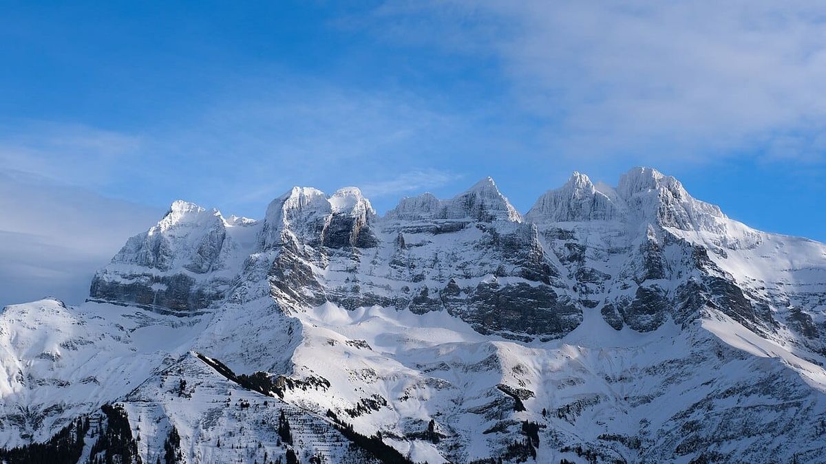
Right on my doorstep stand the Dents du Midi. Seven limestone peaks, 3,257 metres at the Haute Cime, and in the evening light you can clearly make out the horizontal beds stacked in the cliff face. Each one is an old sea floor: warm, shallow water, a shell-strewn platform on the edge of a continent. This was not an ocean. It was a coast — the European margin, sheltered.
To find the open sea you have to drive an hour and a half east: up the Rhône to Sion, then up the Val d'Hérens to Arolla. On the trail that links Arolla to the Lac Bleu, above the hamlet of Satarma, the rock changes utterly. The local geological guide even pins the border down to the metre: here the last gneisses of the continent stop, and the path enters the green rocks. You cross the edge of a world on foot.
What comes next is dark green, covered in yellow lichen, lumpy with rounded shapes: pillow basalts — the blisters lava forms when it chills all at once against seawater. They took shape thousands of metres down, in the Middle Jurassic. That ocean no longer exists, and you can put your hand on its floor.
It was called the Alpine Tethys, and it is not alone in this case. Going back in time over 540 million years, we find five vanished oceans whose opening then closing made the Alps, the Appalachians, the Himalayas and half of the reliefs of Europe - by creating, transforming or deforming the rocks which compose them today.
The most surprising thing is not that they have disappeared. It is that they disappeared according to the same scenario, five times in a row, and that this scenario answers a question that we do not think to ask: what makes a continent move? Not a force that pushes him. A weight that pulls him, thousands of kilometres, downward.
Summary
- A starting scene — the Upper Ordovician, ≈ 450 Ma
- The three-step mechanism
- The five Tours at a glance
- I. Cambrian – Silurian — the assembly of Laurussia
- II. Devonian – Carboniferous — the march towards Pangaea
- III. Permian – Triassic — the Cimmerian relay
- IV. Jurassic – Cretaceous — Pangaea breaks apart
- V. Cenozoic — the final closure
A starting scene: the Upper Ordovician (≈ 450 Ma)
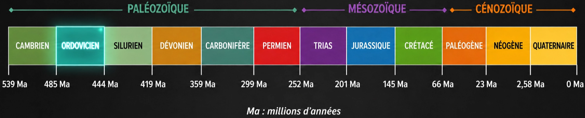
To situate the actors, let's start with a snapshot of the Lower Paleozoic. The continents are then scattered around the Panthalassa super-ocean. Laurentia, Baltica and Avalonia are not yet united: between them the Iapetus ocean closes.
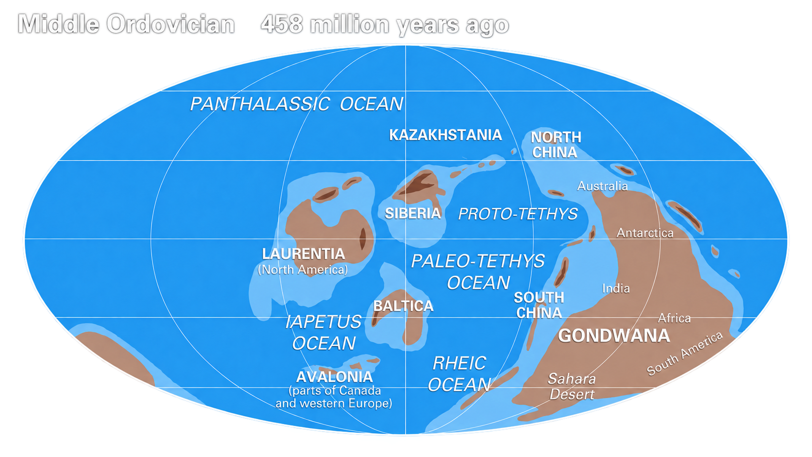
- Laurentia will form the heart of North America, with Greenland and Scotland.
- Baltica, that of Northern Europe: Scandinavia, Baltic countries, Russian plain.
- Avalonia, smaller, will find itself split on both sides of what is now the Atlantic – England, Wales and southern Ireland on one side; Atlantic coast of Canada and New England on the other.
- Gondwana, an immense southern continent, will give rise to a large part of the current continents of the southern hemisphere: Africa, South America, Antarctica, Australia, India and Madagascar, as well as Arabia. Its northern margin will also provide the continental fragments which will play the leading role in everything that follows.
To the south, the Rheic Ocean, open since the Lower Ordovician, continues to widen; to the east already extends the Proto-Tethys, an older ocean occupying areas located even further to the northeast. The Paleotethys did not open until later, in the Devonian.
On the living side, the contrast between the oceans and the continents is very marked. The seas are already rich in biodiversity: trilobites, brachiopods, graptolites, first cephalopods, corals and crinoids developed during the great Ordovician diversification. The first fish, still without jaws, are also present.
The continents, on the other hand, remain almost entirely bare. Life there is very limited: only small primitive plants, close to mosses and liverworts, are beginning to colonize the coastal wetlands. No land animal is yet truly established. Vascular plants, the first forests and a diverse terrestrial fauna will appear later, especially in the Silurian then the Devonian.
The three-step mechanism
The same cycle comes back constantly, in three stages - and the order counts, because it is he who says who commands:
- An ocean floor ages, cools, and becomes heavier than the mantle that supports it. It sinks into it (subduction) — and as it sinks, it pulls on the plate still attached to it on the surface. This already-submerged part is called the slab (panneau), shortened to slab: it is the slab that pulls, and it is the only driving force behind the entire story that follows.
- Pulled by this weight, the plate tears where it resists the least: an ocean opens (rift). The ridge is not a source that pushes, it is the tear itself; the asthenosphere rises there to fill the void, not to remove it.
- When there is no more floor to consume, the traction ceases: the continents come into contact and their collision raises mountains.
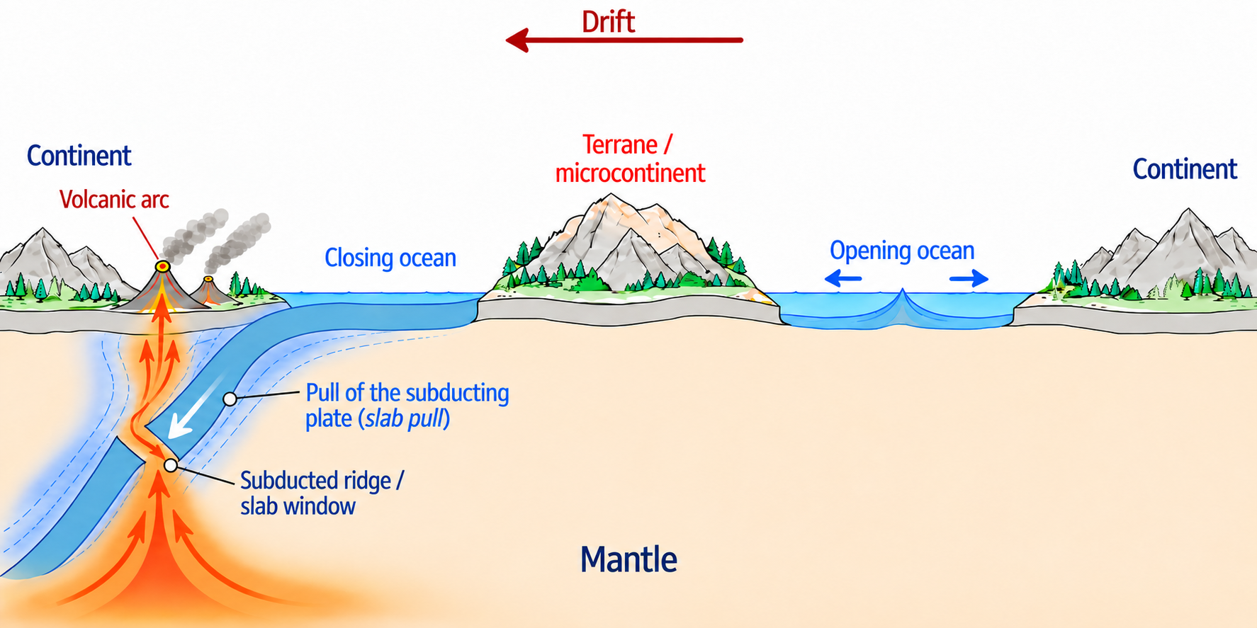
Along the northern margin of Gondwana, this cycle will replay itself block after block: a continental fragment is torn from the margin and carried north by the receding trench; behind him a new ocean opens to fill the void, and before him the older ocean closes. Then comes the relay: this new ocean ages in turn, begins to dive, and it is he who will tear off the next fragment.
The blocks follow one another in a row, each one shifted by several tens of millions of years from the previous one, so that an ocean is always born somewhere while another finishes dying. This regular shift is not accidental: the ridge whose engulfment triggers the first departures is oblique to the margin, and its point of entry into the trench sweeps it from one end to the other, weakening the segments one after the other. This is the critical point of the whole model — the one that explains why the blocks go in a row and not in one piece — and it is the subject of a separate article (forthcoming).
One ocean, three names. Proto-Tethys, Iapetus, Tornquist Sea: these are three names for a single body of water, depending on which shore you look at. Proto-Tethys off Gondwana, Iapetus and Tornquist in its northwest gulfs.
The five Tours at a glance
From the Paleozoic to the Cenozoic, five Tours of this cycle are enough to tell the whole story: each time, an ocean closes where one block arrives while another opens in its wake. Here is the complete score — to keep in front of you while reading.
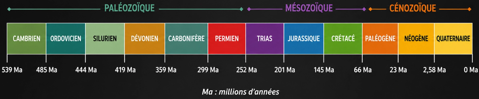
| Tour | The block in motion | The ocean that dies, the ocean that is born | Current mountains and tracks |
|---|---|---|---|
|
I
Cambrian – Silurian
540 → 420 Ma
|
Avalonia, then Baltica towed |
Closes
Iapetus, Tornquist Sea Opens
Rheic |
Caledonides Scottish Highlands, Northern Appalachians |
|
II
Devonian – Carboniferous
420 → 300 Ma
|
the hunical ribbon (ex-Cadomia) |
Closes
Rheic Opens
Paleotethys, and the Rheno-Hercynian basin |
Variscan and Alleghanian Armorican massif, Bohemian massif, the Lizard |
|
III
Permian – Triassic
300 → 200 Ma
|
the Cimmerian blocks |
Closes
Paleotethys Opens
Neotethys |
Sutures hidden since Pontides (Türkiye), Bentong-Raub (Malaysia) |
|
IV
Jurassic – Cretaceous
200 → 66 Ma
|
India and Arabia, plus the Adriatic block |
Closes
Neotethys (beginning) Opens
The Atlantic, the only exception in the story, and the Alpine Tethys |
No collision Palisades (New York), Paraná–Etendeka, Chenaillet |
|
V
Cenozoic
66 → 0 Ma
|
India, Arabia and Africa arrive |
Closes
Neotethys (late), Alpine Tethys Opens
Liguro-Provençal, Tyrrhenian, Aegean basins |
Himalayas, Zagros, Alps Tibet, Zagros, ophiolite from Oman |
I. Cambrian – Ordovician – Silurian: the Laurussia assemblage
Why does a continental block break away, and why at this time rather than another? The first round of the cycle answers both questions.
The initial situation is not a calm ocean that a rift would disturb. Since the Neoproterozoic, the northern margin of Gondwana has been an active margin: a trench there engulfs, towards the south, the floor of the vast ocean which separates it from Laurentia. So the engine is running before the story begins.
The actors are in place. To the northwest, Laurentia: present-day North America, Greenland, part of Scotland. Further south-east, Baltica, the future core of Northern Europe : it separated from Laurentia around 600–550 Ma, when Iapetus opened between the two. It passed the Cambrian in the high southern latitudes, neighboring Gondwana but separated from it by the Tornquist Sea, and turned around compared to today.
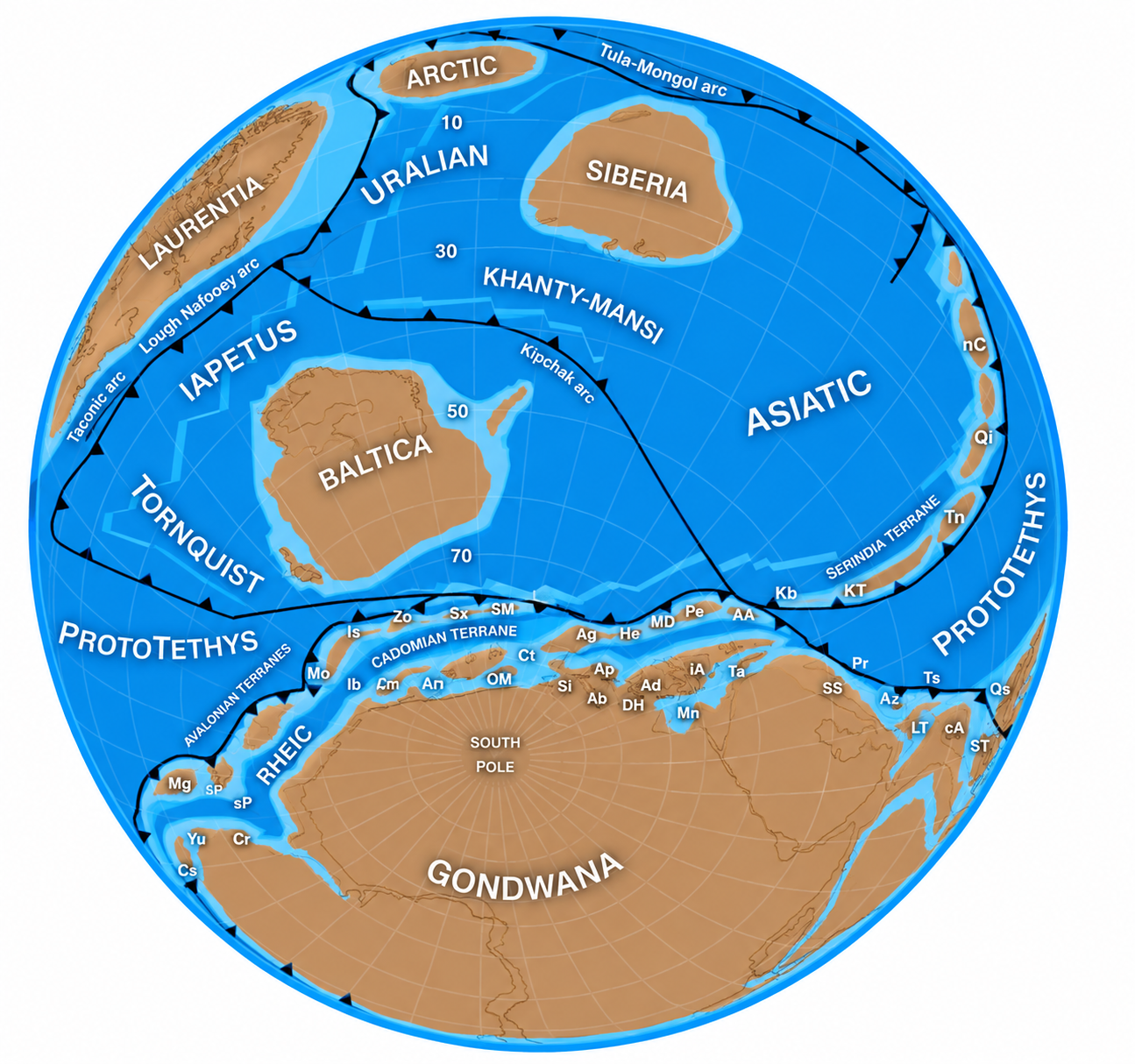
Then, for a hundred million years, nothing comes off. The Gondwanan Trench works without pulling anyone out, because a young ocean floor is still too light to pull hard. It must age, cool and become heavier.
Around 500 Ma, the lock breaks. The ridge of Proto-Tethys, oblique to the margin, in turn arrives in the trench: it lifts the last brake on buoyancy and, by heating the margin from below, designates the place where it will give way. The western segment breaks, and Avalonia is torn away. It is not drifting on its own: the trench is moving back north and taking it with it, because Avalonia is on the overriding plate. Behind it, to fill the void left, a new ocean opens - the Rheic. He is not the cause of departure, he is the scar.
Meanwhile, the same ocean is attacked from the other side: trenches open off Laurentia, and the arcs they generate come up against its margin. Eaten at both ends, the Iapetus quickly closes. And Baltica, sewn to the floor which dips on that side, is towed towards the north by pivoting more than a hundred degrees - not attracted by a destination, but pulled by the weight of the slab to which it is attached.
The meetings then follow one another. Around 450 Ma, Avalonia docked with Baltica and the Tornquist Sea disappeared. Between 430 and 400 Ma, the couple struck Laurentia. Iapetus no longer exists, the Caledonian orogeny raises its mountains, and the three blocks are welded into a new continent: Laurussia, which is also called Euramerica or the continent of Old Red Sandstone. Note Avalonia's place in this story: leaving first, she arrives in the middle, and she is one of the three architects of Laurussia - not a latecomer who came to stick with it.
The ocean that gave its name to the cycle. In 1966, Tuzo Wilson published an article with a title in the form of a question: “Did the Atlantic close and then re-open?” » Its starting point is an anomaly. On either side of the Caledonian-Appalachian chain, the Cambrian faunas are not similar, even though the areas are contiguous today. His answer: an older ocean closed there, before the Atlantic opened at almost the same place. This disappeared ocean is the Iapetus. The “Wilson Cycle” is so named because of Laurentia and Baltica — two continents that separated and then reunited.
Current traces
The Caledonian orogeny left major traces around the current North Atlantic. Its roots, now very eroded, are exposed in particular:
- in the Highlands of Scotland;
- in Ireland and the north of England;
- in Norway and western Sweden;
- in East Greenland;
- in the northern Appalachians of North America.
Two less visible traces deserve to be noted.
- The suture of the Iapetus – the scar left by an ocean when it closes – crosses Great Britain from west to east, between Scotland and England: it is still today, on either side, the limit between two fossil worlds which have nothing in common – Wilson's own observation.
- The trans-European suture zone, heir to the Tornquist Sea, runs under the Northern European Plain from the North Sea to the Black Sea: the largest geological boundary on the continent, entirely buried under sediments.
To remember. Avalonia leaves first and arrives in the middle. Baltica never belonged to Gondwana: it is towed by the floor to which it is welded. And the Rheic is not the cause of Avalonia's departure—he is the scar.
II. Devonian – Carboniferous: the march towards Pangaea

Why did the following blocks wait a hundred million years? If the first round mechanic was general, they should have gone with Avalonia. This is actually what they tried to do.
The failed attempt
At the very beginning of the Ordovician, while Avalonia moved away to the west, the margin segment located further east also began to tear apart. A block - Cadomia, which will become the Hunic ribbon - opens out of Gondwana, and an embryonic Rheic is outlined behind it. Then everything stops. The ridge has not yet arrived under this segment: the floor which plunges there is still young, still too light, and the traction insufficient. The aborted rift closes, the nascent ocean is reconsumed, and Cadomia rejoins Gondwana in the Middle Ordovician.
This failure is the best proof of the mechanism. A model that only explains its successes explains everything and therefore nothing; this also predicts where and when nothing happens. Without a ridge arriving at the trench, no departure. Why a young floor hardly pulls at all, how the arrival of a ridge lifts this brake while designating the place where the margin will give way, and what forces are really at play: this is the heart of the mechanism, and it is the subject of a separate article (forthcoming).
The relay
We had to wait for the sweep to reach this area. The ridge, oblique to the margin, progresses along the trench at a few centimetres per year — a few thousand kilometres in a few tens of millions of years. When it finally reaches under the eastern segment, the bolt jumps a second time.
And the passing of the baton can be seen with the naked eye. What is pulling now is the Rheic itself: the ocean born a hundred million years earlier in the wake of Avalonia. Its floor has aged, cooled, become heavier, and it in turn plunges under the northern margin of Gondwana. Each new ocean becomes, one turn later, the executioner of the next block.
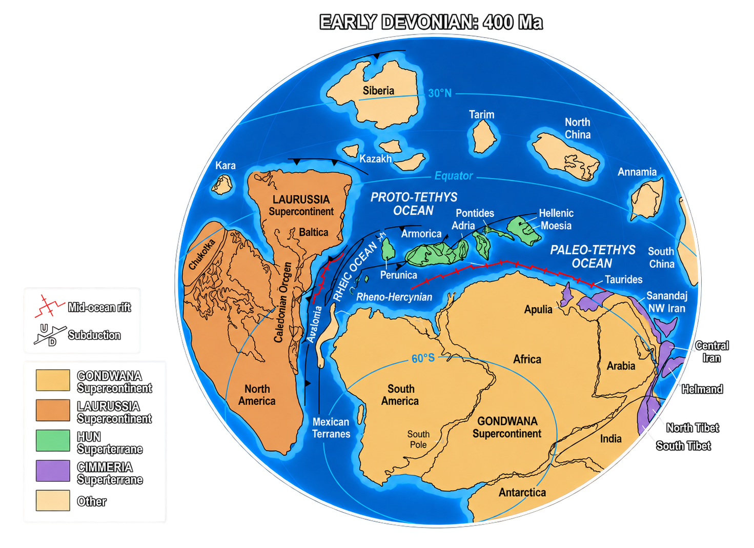
In the late Silurian, the hune ribbon was torn from the Gondwanan margin and carried northward by the receding trench. Before him, the Rheic is consumed; behind it opens the next ocean, the Paleotethys. In the Devonian, these lands therefore form a mobile zone between Gondwana and Laurussia - not a raft crossing, but a ribbon pulled by its front edge.
Its very form betrays it. The northern edge of the ribbon, the one facing the trench, is an active margin: metamorphism, plutonism, arc magmatism. Its southern edge, the one which looks out over Gondwana which it has just left, remains a passive margin where sediments are quietly deposited. A block pushed by a ridge would have no reason to present this asymmetry. A block pulled from the front, yes.
L'argument décisif
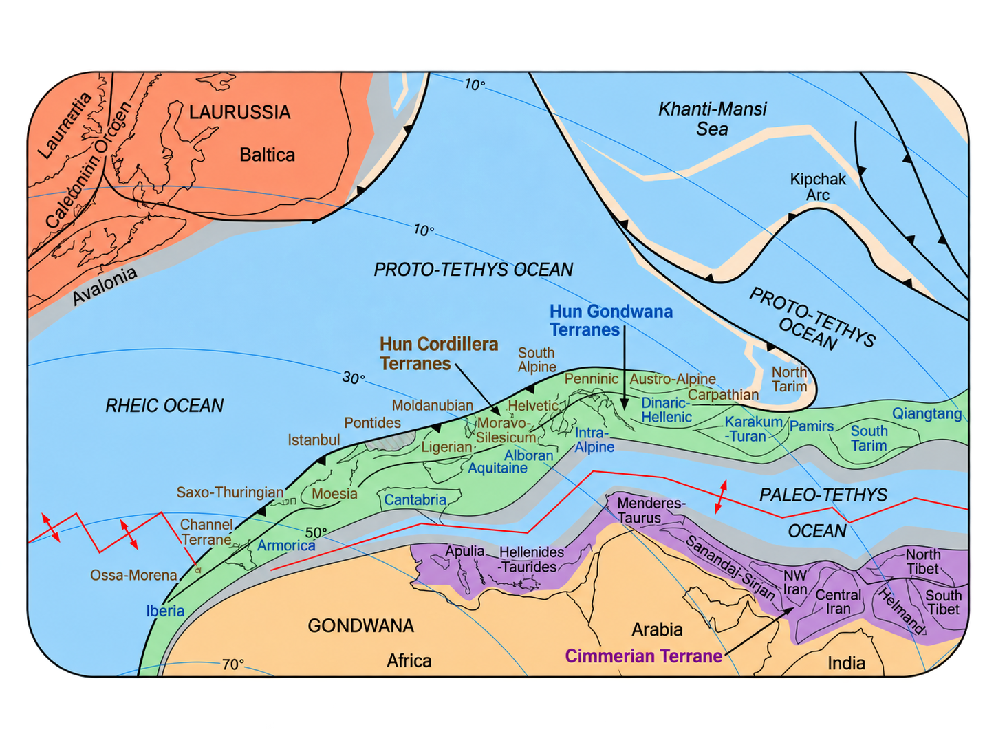
The most interesting thing happens on the other side of the trench. The plunging Rheic floor belongs to the same plate as the southern margin of Laurussia - and the traction of the slab is not only exerted on what it pulls in front, it also pulls on what remains attached to it behind. In the Devonian, this margin was torn apart from the interior and a narrow ocean basin opened up: the Rheno-Hercynian ocean.
This is where the demonstration ends. This rift is not behind an arc, but in the plunging plate itself. Its volcanism is purely extensive, without any signature of subduction, and fragments of mid-ocean-ridge-type ocean floor have been preserved there - at the Lizard in Cornwall, in the Giessen and Harz layers. No ridge push can produce that: there was no ridge yet. Only the pull of a slab that is already sinking can open an ocean inside the plate that it is swallowing.
Note the echo with the previous chapter. There, the diving plate had held, and it had towed an entire continent—Baltica. Here it gives way and tears. One force, two outcomes, depending on whether the plate resists or breaks.
Pangaea
In the Carboniferous, the convergence completes its work: the Rheic disappears entirely, then Gondwana comes up against Laurussia. The collision raises the Variscan orogeny in Europe and the Alleghanian orogeny in North America. The continents now form only one mass: Pangaea.
Current traces
The European mound grounds are today incorporated into the ancient massifs of Western and Central Europe. Traces of it can be found in:
- the Armorican Massif;
- the Massif Central;
- the Vosges and the Black Forest;
- the Bohemian Massif;
- the northwest of the Iberian Peninsula;
- Saxony and Thuringia, the base of which bears the name of one of the blocks of the ribbon.
These regions contain basements of Gondwanan origin, Paleozoic sedimentary series, granites and metamorphic rocks formed during drift, subduction and then collision. They tell the complete journey: removal from Gondwana, crossing towards the north, integration into the Variscan chain.
Two traces are worth adding, because they can be seen without being a geologist. The Lizard Complex, at the tip of Cornwall, is a piece of ocean floor and mantle lifted onto the continent: it is a fragment of the Rheno-Hercynian Ocean, material evidence of an open ocean inside a sinking plate. And the coal basin which runs from Nord-Pas-de-Calais to the Ruhr, then to Silesia, occupies the depression formed in front of the Variscan front, where the weight of the emerging chain caused the crust to bend. The coal that fueled the European industrial revolution accumulated in the furrow dug by this collision.
To remember. The Rheic, born in Tour I, becomes the executioner of Tour II: each new ocean kills the next block. The failure of Cadomia proves the mechanism better than its successes. And the Rheno-Hercynian basin opens inside the plate being swallowed — an ocean without a prior ridge.
III. Permian – Triassic: the Cimmerian relay

Is there a need for a ridge at each turn? The previous chapter could lead us to believe this, and that would be a weakness: a mechanism which requires such a particular coincidence each time does not explain much. The third round says no.
Just wait
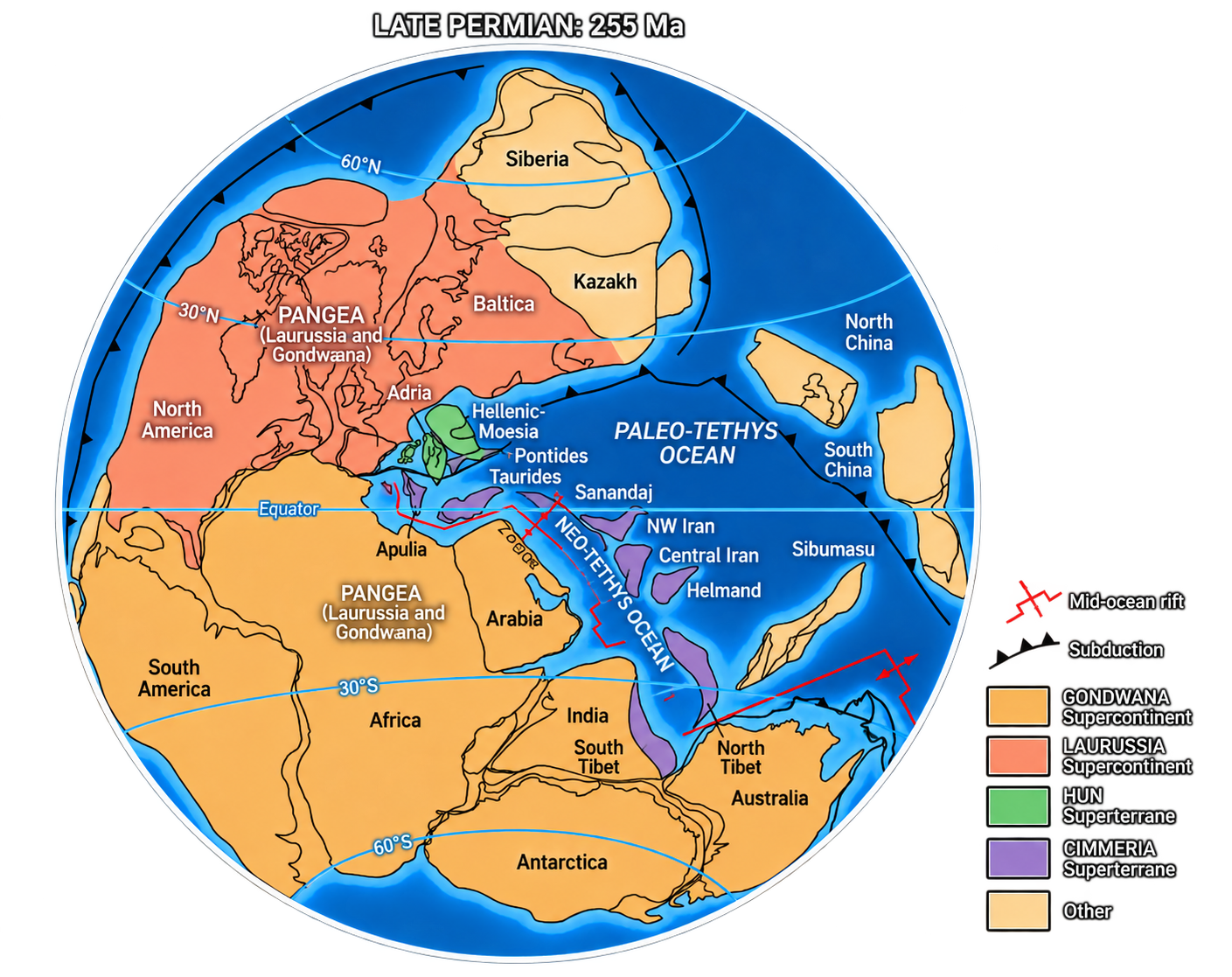
In the Permian, Pangaea was almost assembled. The Rheic has disappeared, and the Paleotethys still occupies a vast oceanic domain south of Eurasia, where its floor plunges below the continental margin. For a long time, nothing came off: as long as a still relatively light portion of this floor entered the trench, the traction remained weak. Then the floor aged. The slab, having become quite heavy, began to move backward, and the Cimmerian blocks were torn away from the northern margin of Gondwana.
No ridge was swallowed here. Aging alone was enough. In the two previous tours the ridge softened the overriding margin segment by segment: it decided where the tear would open. Here the blocks sit on the downgoing plate — there is no overriding margin to soften, only a slab that has to grow heavy enough. The engine has not changed: it is still the weight of the slab.
And the geometry can be reversed
A second change easily goes unnoticed, and it is the most instructive. In the two previous rounds, the trench was on the Gondwana side: it was moving backwards, and the block placed on the overlapping plate was taken with it. This time the trench is on the other side — the Paleotethys plunges northward, beneath Eurasia. The Cimmerian blocks are therefore no longer on the overlapping plate: they are on the plunging plate.
And they still go north. The slab that is sinking under Eurasia is pulling on the entire plate that remains attached to it — including the margin of Gondwana, which is tearing itself apart. The Neotethys opens in this tear, and the Cimmerian blocks are towed towards the trench.
This is exactly the mechanism of the Rheno-Hercynian: an ocean which opens inside the plate being swallowed. With one difference in size - in the Devonian, the tear had produced only a narrow basin; here it produces a major ocean. And it is also the mechanism that towed Baltica in chapter I. Three different geometric situations, a single engine.
The collision
In the Triassic, the Cimmerian blocks reached the southern margin of Eurasia. Their collision completes the closure of the Paleotethys and leaves a series of ancient sutures and chains, often taken up and subsequently masked by Alpine and Himalayan collisions. The Neotethys becomes the great ocean which now separates Gondwana from Eurasia: the setting for the last two rounds.
What this tour demonstrates. The engine is the weight of the floor, nothing else. The trigger can vary — sunken ridge or simple aging. The geometry can reverse — the block can travel on the overlapping plate or the plunging plate. The result does not change: a block torn from a continent, an ocean which closes in front of it, an ocean which opens behind it. A mechanism that survives this kind of permutation is a mechanism; a coincidence would not survive there.
Current traces
The Cimmerian blocks do not form a compact continent but a series of dispersed fragments, today distributed between Eastern Europe, the Middle East and Asia:
- Türkiye and Anatolia;
- Iran;
- Afghanistan;
- Tibet;
- Southeast Asia, around Thailand, Malaysia, Myanmar and Indochina.
They are recognized by their ancient continental bases, by sedimentary series deposited on the edge of Gondwana, by ophiolites - scraps of ancient ocean floor hauled up on the continent - and by suture zones marking the location of the disappeared Paleotethys.
Two sutures are clear enough to follow on a map. In Northern Türkiye, along the Pontides, runs the Paleotethys scar, dotted with ophiolites and subduction complexes. And in peninsular Malaysia, the Bentong-Raub suture crosses the country from north to south: it separates two halves of different origins and there also marks the disappearance of the Paleotethys. The border between two ancient worlds passes beneath the Malay jungle.
IV. Jurassic – Cretaceous: Pangaea breaks apart

Is it all traction? Three rounds of the cycle have given the same answer, and it would be suspicious if there were never any exceptions. There is one, it's huge, and it's the one you see every time you look at a world map.
How we make the difference
Once the ocean is formed, the two cases are indistinguishable: ridge, two passive margins, new floor. We cannot therefore decide by looking at the result. We must look at what has preceded openness — and there, the two hypotheses predict opposite things.
If it was traction that opened the rift, no heat intervened. The strength comes from a cold slab flowing elsewhere, sometimes thousands of miles away. Nothing must therefore precede the opening: the volcanism remains modest, it accompanies the rift instead of announcing it.
If it is a rise of the coat, the order is reversed. The warm mantle arrives first, under a still intact lithosphere. It must therefore leave a trace before the rift exists: an enormous basalt effusion - millions of cubic kilometres in a few hundred thousand years - and distributed on either side of the future tear, since it is not yet open at the time it is put into place.
The test therefore consists of one question: is there a large basaltic effusion prior to the rupture, and present on either side of the future margin? If so, the coat has something to do with it. If not, it's traction.
Let's pass the oceans of the previous chapters to this test. The Rheic, Paleotethys, Neotethys and Rheno-Hercynian clearly show extensional volcanism, but of incomparably lower volume, contemporary with the rift and not earlier. Verdict: traction. Consistent with all of the above.
The Atlantic: the exception
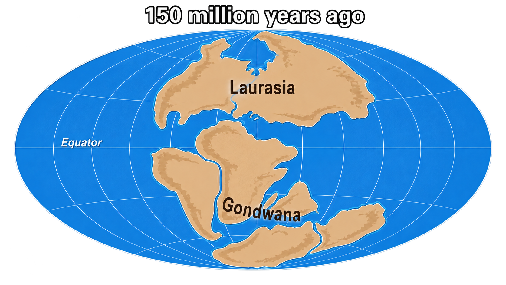
Around 230 Ma, in the Upper Triassic, Pangaea began to crack. A chain of ditches opens from Morocco to Nova Scotia — Argana, Fundy, Newark, Hartford — and fills with red sandstones and lakes. This rift, by itself, proves nothing. Pangaea cracked almost everywhere at this time, and most of these divides failed.
Then, around 201 Ma, at the very end of the Triassic, something much more massive happened. In less than a million years, eleven million square kilometres of basalts spread: Brazil, West Africa, Eastern North America, Iberia. Lava invades already dug ditches - the Palisades sill injects itself into the filling of the Newark basin, the North Mountain Basalt is placed in that of Fundy. It is therefore not the rift that this magma triggers: the rift has been waiting for it for thirty million years. It's the breakup. The first ocean floors only formed later, between 190 and 175 Ma. Verdict: mantle rise.
The same test gives the same result a second time, in the Lower Cretaceous. The South Atlantic rift began around 145 to 138 Ma: deep lakes were established in the Campos and Kwanza basins, on either side of the nascent tear. Then, around 134 Ma, the basalts of Paraná in Brazil and those of Etendeka in Namibia spread. They formed a single sheet, which the opening cut in two. Here again, the magma does not dig the rift: it arrives in a rift already there, and causes it to give way. The breakup follows almost immediately — around 130 Ma in the south, only around 112 in the equatorial Atlantic. The ocean spreads from south to north like a zipper being opened. Verdict: mantle rise, again.
A clarification is necessary here, because it changes the scope of the test. In both cases, the rift precedes the basalt, sometimes by tens of millions of years. What the mantle rise triggers is not the fissure — it is the passage from the fissure to the ocean. Pangaea has produced dozens of rifts which have never produced an ocean: the Benue rift, in Nigeria, is a dead arm of the South Atlantic opening, and the Rio Grande rift, today, is another which will probably never succeed. What sets the Atlantic apart is that a plume arrived in the right place at the right time, and transformed one more gap into a passive margin.
Two openings, the same diagnosis twice. The Atlantic is indeed the exception of this entire article: the only ocean in this story whose opening cannot be explained by the traction of a diving slab. Which does not mean that it is unrelated: Pangaea was surrounded by subductions, and the respective part of the plume and traction in its dislocation remains debated. What is established is that here, for the first time, the coat has a real role.
And the initial thesis is not contradicted: it was not the heat that caused it. The plume lifted Pangaea by one to two kilometres, and a dome of this size spreads under its own weight - it is again gravity at work, applied this time to a raised relief rather than to a sinking slab.
And then? A sliding ocean
The plume only lit the fuse. An effusion of this magnitude takes place in a few hundred thousand years, then it's over - and the Atlantic has continued to expand for two hundred million years. What maintains the opening, once the plume is extinguished?
Not the ridge, at least not in the way we imagine it. There is no thrust at the axis, no jet which would push back the two banks. The oceanic lithosphere, moving away from the axis, cools, thickens and sinks: the floor goes from 2,500 metres deep at the ridge to more than 5,500 metres after a hundred million years. This results in a slope. A ridiculous slope - a meter every few kilometres - but it runs for thousands of kilometres and carries a plate a hundred kilometres thick. This plate is slipping. This is called “ridge push”; we should say gravity sliding. Nothing grows at the ridge, but something runs down its sides, and that is enough.
And the verification is in the numbers. Gravity sliding weighs approximately 10¹² newtons per meter; the pull of a plunging slab, almost 3 × 10¹³ — thirty times more. The plates which have a slab, Pacific, Nazca, Cocos, spin at ten or fifteen centimetres per year. Those that don't have one — South America, Africa, Antarctica — drag themselves along in twos or fours. The Atlantic is expanding at the speed of a growing fingernail, the western Pacific at the speed of a hair. This difference is not a measurement detail: it is exactly the difference between the two engines. The speed of an ocean is the signature of what pulls it.
The table at the beginning then takes on its full meaning. Traction opens quickly and without magmatic prelude; a mantle rise opens after an enormous prelude, then lets the ocean expand slowly, for lack of an engine of its own. The Atlantic is the second case, and its few centimetres per year say so.
Why the subductions of the Pacific cannot separate the two shores of the Atlantic - the geometry of the Andes, the San Andreas, the slabs of Calabria and Crete: see the article on the mechanism (to be published).
In the east: the rule
While the Atlantic opens, the usual mechanism continues to operate on the other side of the world, and this time without exception. The floor of the Neotethys plunges towards the north under the southern margin of Eurasia, and it is this depression which catches the last convoy of Gondwanan blocks: India and Arabia in the lead. The ocean begins to close in front of them.
A more modest fragment begins at the same time, and it is important for the future: between Europe and the Adriatic block a narrow oceanic arm opens in the Jurassic, the Alpine Tethys. It is he who, by closing, will make the Alps - and of which the Chenaillet, at the top of this article, is a piece of flooring.
As for India, it provides the best living proof of the entire article. Pulled by the Neotethyan slab, in the Upper Cretaceous it reached speeds of around fifteen centimetres per year: the known record for a plate carrying a continent, or four to five times the speed at which the Atlantic opened at the same time. Two contemporary oceans, two regimes — the one with a trench goes fast, the one without one goes slowly.
Current traces
The opening of the Atlantic can be read directly in current geography:
- the complementarity of the coasts between South America and Africa;
- the passive margins on either side, those of Brazil, West Africa, the Eastern United States and Western Europe;
- sedimentary basins formed during rifting, often rich in marine deposits and hydrocarbons;
- the Mid-Atlantic Ridge, which still produces ocean floor today.
The volcanic prelude is also observed, and it is more spectacular than the margins. The Palisades, the basalt cliff which borders the Hudson facing Manhattan, belongs to the 201 Ma outpouring; equivalents are found in the Fundy basin in Nova Scotia and along the great Messejana vein, which crosses Portugal and Spain. The basalts of Serra Geral in Brazil and those of Etendeka in Namibia are the two pieces of the second effusion: same rocks, same age, two continents.
To the east, it is the vanished oceans that have left the most astonishing traces. The Chenaillet massif, above Briançon, is a piece of floor of the Alpine Tethys raised on the continent: we walk there on pillow basalts formed at the bottom of an ocean which no longer exists, and the same floor is found in the ophiolites of Liguria and in the Zermatt-Saas units. Further away, the Semail ophiolite, in Oman, is an entire section of Neotethyan oceanic lithosphere – crust and mantle – laid on the Arabian margin in the Upper Cretaceous: the most beautiful outcrop of ocean floor in the world, open to the sky and dry.
One last detail, for the reader's memory. The 201 Ma effusion coincides with the end-Triassic extinction, one of the five great crises of the biosphere. The same mantle event that began opening the Atlantic emptied many of the oceans and continents of their inhabitants — and, by eliminating the dinosaurs' competitors, opened the Jurassic as we know it.
Two halves, two engines
The Atlantic therefore does not result from the closure of the Tethyan oceans. It represents the other half of the system: we create the ocean in the west while we destroy it in the east. But note the asymmetry of the causes. In the east, destruction rules, and neither the opening of the Neotethys nor its closing needed a plume. Only in the west did the mantle have its say — and its word stopped after a few hundred thousand years, leaving an ocean to expand in slow motion for two hundred million years.
This tranquility is temporary. Two small trenches are already eating away at the edges of the Atlantic: the Lesser Antilles arc and the Scotia arc, where the Atlantic floor is beginning to plunge. Neither originated there — both are subductions of Pacific origin that receded eastward and entered the Atlantic. But it doesn't matter where they come from: if one of the two spreads, this old floor - the oldest and heaviest in the ocean, stuck against the margins, now cold enough to sink - will provide the missing slab, and the Atlantic will close as the Iapetus closed before it, almost in the same place.
To remember. The Atlantic is the only exception in the story: a plume opened it. But the rift had been waiting for it for thirty million years — the mantle didn't widen the crack, it made it give way. And since then, for lack of a sign, the Atlantic has been expanding five times slower than the oceans which have one: the speed betrays the engine.
V. Cenozoic: the final closure

And how does it stop? The previous four chapters told of departures. This one tells of arrivals, and it answers the question that remains: if the machine has been running since the Neoproterozoic, why are half of its engines stopped today?
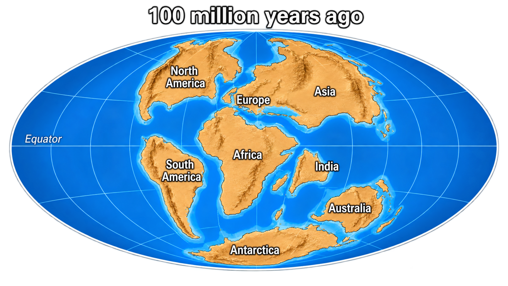
In the Cenozoic, the dynamic initiated in the Mesozoic came to an end. The floor of the Neotethys, swallowed by the Eurasian trench, is exhausted; the last large southern blocks that it was towing — India, Arabia, Africa — reached the southern margin of Eurasia and collided with it. This closure does not produce a single continuous chain, but a vast ensemble of collision chains, high plateaus, residual basins and oceanic sutures: the last major stage of the Tethyan cycle.
India, Arabia, Africa
India, torn from Gondwana in the Cretaceous and towed northward by the Neotethyan slab, reached Asia around fifty million years ago. The collision builds the Himalayas and raises the Tibetan plateau, whose crust today reaches seventy kilometres thick – double that of normal continental crust. It still continues, which explains the extreme altitude of the region and its high seismic activity.
Further west, Arabia was caught by the same trench and collided with Eurasia in the Miocene. Its collision closes the Neotethyan marine domains of the Middle East and builds the Zagros, a large folded chain which crosses Iran and Iraq.
Finally, the convergence between Africa and Europe reduces the last western Tethyan basins. It participates in the formation of the Alps - resulting from the closure of the Alpine Tethys opened in the Jurassic -, the Apennines, the Dinarides, the Hellenides, the Atlas and numerous Mediterranean chains. The current Mediterranean corresponds to a complex residual domain, inherited from this incomplete closure.
What stops the machine
We readily imagine that the movement stops because two continents collide: the obstacle blocks the course. This is not what is happening, and India is demonstrating it. After its collision, it continued to advance more than a thousand kilometres — it is this advance that thickened Tibet and still uplifts it. The obstacle didn't stop her.
What has changed is something else, and this can be seen in its speed: fifteen centimetres per year before the collision, four to five after. A factor of three, lost at the precise moment the continent reaches the trench. The reason is that the trench can no longer swallow anything. A continental lithosphere is too light to sink; it blocks the entrance. The already embedded slab continues to pull for a moment, then detaches itself from the plate it was towing and sinks alone into the mantle, abandoned. The traction stops. All that's left is momentum and residual forces — enough to sustain a collision, not enough to cross an ocean.
Three causes combine in this slowdown, and they all point to the same engine.
- An obstacle, but not the one you think. It is not Asia which blocks India from the front: it is the Indian continental crust which is too light to dive. It enters the trench, refuses to flow, and seizes the mechanism.
- A breakup. Around 45 to 40 Ma, the Neotethyan slab — still hanging under India, pulled downwards, but nothing left to power it — suddenly broke. The magmatism of Ladakh and Kohistan records this shift.
- A breakdown. There was no more Neotethys: the trench had swallowed everything. The engine was not braked, it ran out of fuel.
All three say the same thing from three angles. A continental plate does not move on its own; it is towed by the ocean floor which precedes it. When this floor is exhausted, towing stops.
The live mechanism
There remains one place where the machine is still running, on a small scale, under our instruments — and that is the Mediterranean, the only place in this article where the reader can check for himself.
Look at Corsica and Sardinia. They belonged to the European margin, backed by Provence and Languedoc. Around thirty million years ago, the European margin began to crack: the Gulf of Lion and the Valence furrow sank, the crust thinned. Then, between 21 and 16 Ma, everything went out of control. In just five million years, the Corso-Sardinian block pivoted by almost fifty degrees and tore itself away from Europe. An ocean floor sets up behind it: the Ligurian-Provençal basin. Half a quadrant of rotation in the time it takes for the Alps to gain a few hundred metres.
And the engine doesn't stop there. Around 9 Ma, then again around 5, the tear resumed further east and opened the Tyrrhenian Sea. The retreat of the Calabrian slab did not slow down along the way: it jumped backwards, abandoning the basin it had just created to open another. The aeolian arc — Stromboli, Vulcano — marks the current position of this machine.
It is, line for line, the story of Avalonia and the Rheic Ocean – a block torn from its margin by a receding trench, an open ocean at its back – but on a tenth of the scale, dated to the nearest million years, and measurable with GPS. And if one example is not enough, the Aegean Sea provides a second, even younger one: the Hellenic Trench recedes toward the southwest, Crete straddles its forearc, the Aegean stretches behind, Santorini and Nisyros are its volcanic arc, and Anatolia is expelled westward at two centimetres per year. With one difference that deserves to be said: here, no ridge has come to weaken the margin beforehand. The floor submerged under Calabria is, on the contrary, the oldest and heaviest that survives from the Tethys, and it is this density alone which causes the trench to recede. The Mediterranean therefore demonstrates the transport of blocks, not the ignition of subductions - but it is transport that was at issue in the four previous chapters.
These are models. Nothing in the first four chapters requires taking our word for it: the mechanism works today, a few hours by plane, and we can watch it.
Current traces
This final closure can still be read directly in the large current reliefs:
- the Himalayas and Tibet, linked to the India–Asia collision;
- the Zagros, linked to the Arabia–Eurasia collision;
- the Alps and the Mediterranean ranges, linked to the Africa–Europe convergence;
- active earthquakes in the Himalayas, Iran, Turkey, Greece and Italy, which show that convergence is not complete.
Current remains
The Tethyan oceans did not disappear without traces. Part of their heritage remains in today's seas and basins: Mediterranean, Black Sea, Caspian Sea, and certain internal basins of Anatolia, Iran and Central Asia.
A precaution, however, because these basins do not all have the same age or the same origin. The real vestige is the eastern Mediterranean: under the Ionian and Herodotus basins lies an ocean floor among the oldest still in place on Earth - estimates range from the Triassic to the Permian, and the debate is not closed; some authors even dispute that it is oceanic crust, and see it as extremely thinned continental crust. The western Mediterranean, on the other hand, is not a remnant at all: the Ligurian-Provençal basin and the Tyrrhenian Sea are less than thirty million years old and were made by the recession of the trench described above. Same thing for the Aegean. The Black Sea is a Cretaceous back-arc basin, and the status of the southern Caspian remains debated.
In other words: half of the Mediterranean is a vestige of the Tethys, the other half is a recent creation of the very mechanism of this article.
But the most direct traces are found in collision chains. We observe sutures, that is to say the lines where the ancient oceans closed - that of the Indus-Yarlung in Tibet, that of the Zagros in Iran -, as well as ophiolites, fragments of ancient ocean floor now carried aloft. Some rise to more than four thousand metres. From the bottom of the oceans, hoisted to the tops of the mountains: it is the least questionable signature of the entire cycle.
Epilogue
Five eras, one mechanism. At each turn, an aged, cooled ocean floor, heavier than the mantle that carries it, ends up sinking somewhere — and everything else flows from it: the blocks torn away, the open oceans behind them, the continents assembled, the chains lifted. Rifts were never causes. They were the breaking points of a system pulled from below.
And if the machine stopped along the Alpine belt, it was not because the continents touched each other: it was lack of floor to pull.
Sources and framework of the story
This account follows the reconstruction of Stampfli & Borel (2002) and the hunical ribbon model. It is a model, not a consensus: the nature, number and route of the hunical terrains remain debated, and other reconstructions cut up the northern margin of Gondwana differently. The facts on the ground cited here – ophiolites, sutures, basaltic effusions, speeds measured with GPS – are not in question; it is their telling of the story which is a choice of model.
Ruban, D., Al-Husseini, M. & Iwasaki, Y. (2007). Review of Middle East Paleozoic plate tectonics. GeoArabia, 12(3), 35–56. https://doi.org/10.2113/geoarabia120335
Stampfli, G. M. & Borel, G. D. (2002). A plate tectonic model for the Paleozoic and Mesozoic constrained by dynamic plate boundaries and restored synthetic oceanic isochrons. Earth and Planetary Science Letters, 196(1–2), 17–33. https://doi.org/10.1016/S0012-821X(01)00588-X
Wilson, J.T. (1966). Did the Atlantic close and then re-open? Nature, 211, 676–681. https://doi.org/10.1038/211676a0